Are you thinking about traveling along the Carretera Austral to enter the wonderful Chilean Patagonia? Then you’ve come to the right place, here’s an incredible itinerary to help you plan your trip.
Day 1: Cochamó
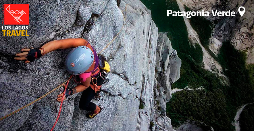
The name Cochamó is derived from the Mapudungun words Kocha-mo, meaning “where the waters meet.” This commune offers various attractions for both families and adventurers, with the Cochamó Valley standing out, known as the “Chilean Yosemite.” It is a multi-day route that traverses wonderful places surrounded by enormous rock walls where world-class climbing routes can be practiced.
What to visit:
In this commune, you will find the Parish of María Inmaculada, a building dating back to 1890 and the tallest structure in the area, located in front of the Reloncaví Estuary coast.
In the “El Bosque” sector, approximately 15 minutes by vehicle from the commune, you will find the Coihue de Los Columpios, which offers a beautiful panoramic view of the Reloncaví Estuary, the town, and the surrounding nature. For only $2,500 pesos, you can enjoy this thrilling adventure.
At the beginning of the Cochamó Valley, there is a turnoff leading to the Hidden Waterfall, a beautiful waterfall with native vegetation from the region. The entrance fee is $2,500 pesos, and the place offers lunches and a traditional Chilean dessert, mote con huesillos.
Day 2: El Valle
Heading up from Cochamó, you will find El Valle. This place can be reached by walking or by hiring horseback riding services. During the day, you can schedule an early ascent to see the famous Natural Slides of Cochamó, which after 3-4 hours will dazzle you with their waters and a granite wall in the background. In this place, it is essential to be very cautious to avoid any accidents, as there is no phone signal and emergency teams do not have direct access.
Day 3: Río Puelo
Its name is derived from the Mapudungun word Puelco, meaning “Water of the West.” This locality is located 35 km south of Cochamó and is known for its tributary, the Puelo River, which originates in the province of Chubut, Argentina. Before reaching the town, there is a turnoff towards Lake Tagua Tagua. There are 2 ferries that make the lake crossing, taking 1 hour from Punta Canelo dock to Puerto Maldonado. Here begins the Puelo River Valley, with unique, secluded landscapes and traditions that are essential to understand the way of life in such deeply rooted places.
After about 45 minutes by car, we find the town of Llanada Grande, where the first highlight is El Salto, located in Campo Eggers, with the entrance next to the airfield. To enjoy this place, you must pay CL$1,000 pesos, and after walking along the path for about 15 minutes, you can appreciate the impressive waterfall.
In the afternoon, you can visit Lake Azul, with its intensely blue waters, where you can kayak, take boat rides, and even reach the other end to start a journey to Lake Las Rocas. It is a place of perfect disconnection, ideal for relaxing all afternoon and enjoying the benefits of this sector.
Following the same route, it is possible to reach Primer Corral, Segundo Corral, and Valle Ventisquero, and in this way, get to know the Puelo River better. There is also a border that connects Lake Puelo in Chile with Lake Puelo in Argentina. If you plan to cross the border, we recommend planning well, as it is an international river crossing.
Day 4: Hualaihué
After our visit to Llanada Grande, we can visit the Termas del Sol in the morning, located on the way to Hornopirén. This place has 10 pools ranging from 36° to 45° and offers a family-friendly space with a variety of pizzas and local beers. The pizza with Morchella, a gourmet edible mushroom, is particularly appreciated by both foreign and national tourists.
91 km south of Río Puelo is Hualaihué, a land of fjords, volcanoes, lakes, and rivers. This place is also recognized for the Artesanos de Ribera, who maintain the traditional technique of building Chilote boats. Its capital is Hornopirén.
A must-visit place within Hornopirén National Park are the Río Blanco waterfalls, with crystal-clear waters that originate from the depths of the Southern Andes. To access this place, you need to reach the Río Blanco bridge; on the left is the trailhead, which takes approximately 1 hour and 30 minutes, following the beautiful river and surrounded by native flora and fauna. An entrance fee of CL$2,000 pesos is required. On your return to the village, you can walk along the coast and enjoy the tranquility this place offers.
Día 5: Chaitén
Desde Hornopirén podemos tomar 2 rutas, una de ellas es bimodal, que contempla trayecto mar y tierra. Es una navegación muy atractiva de aproximadamente 5 horas que recorre fiordos y un paisaje siempre verde. Esta ruta va desde Hornopirén hasta Leptepu y de ahí sigue hasta Caleta Gonzalo, que está a 56 km de Chaitén, con un tiempo estimado de 1 hora en vehículo.
Una de las tantas atracciones de Chaitén es el Parque Pumalín. Existen varias rutas de senderismo y podemos destacar algunas que se pueden realizar durante el día.
Sendero Los Alerces: Tiene como objetivo la contemplación de la flora, especialmente de los alerces milenarios, de casi 3,000 años. Es de baja dificultad, su duración es de aproximadamente 40 minutos ida y vuelta, tiene una distancia de 1.4 km y su inicio está a 12.5 km al sur de Caleta Gonzalo.
Sendero Cascadas Escondidas: Posee tres cascadas a lo largo del recorrido. La primera es de mayor dificultad por estar subiendo un valle, a diferencia de las otras que son senderos más planos. El total de esta ruta es de 2 horas, con una distancia de 3.6 km y tiene una dificultad media-alta. El inicio está a 14 km al sur de Caleta Gonzalo, desde el campamento Cascadas Escondidas.
Sendero Ranita de Darwin: Para los amantes de la flora y la fauna, este es uno de los lugares favoritos gracias a sus 3 miradores, de carácter interpretativo. En algunas ocasiones puede ser posible ver la pequeña ranita de Darwin, una especie en peligro de extinción. Es de baja dificultad, con una duración aproximada de 1 hora y 30 minutos y una distancia de 3 km. El inicio está en el camino hacia el campamento Grande, kilómetro 4.2.
Day 6: Futaleufú
From Chaitén to Futaleufú, there is a distance of 151 km, which translates to approximately 4 hours of travel. A mandatory stop on this route is Villa Santa Lucía, where the detour towards Futaleufú is located. Here you will find the La Casa de la Bandera Museum, a commemorative space that highlights a very painful event that occurred on December 16, 2017, a flood that forever changed the lives of the locals in this area.
After this stop, the road to Futaleufú is gravel, and depending on the weather, it affects the duration of the trip. On this route, we can find Lake Yelcho, which originates from the Futaleufú River tributary and joins between valleys, providing a beautiful panoramic view.
Futaleufú, from the Mapudungun meaning “Big River,” is a paradise with an enormous natural heritage of Northern Patagonia. Here you will find most of the tourist services in the area that attract the most adventurous. Its river is notable for its color, beauty, and quality for adventure sports such as kayaking, rafting, and packrafting.
On this route, there are several options for rafting, with different prices and difficulty levels. It is an unmissable experience, as its rapids are recognized worldwide. If you are looking for companies that offer this service, we will leave you this link to our tourist services search engine.
This experience is highly recommended, as it will provide you with unique moments, admiration for nature, and a river that delivers enormous motivation and enjoyment of its magnificent waterfalls.
Day 7: Futa Natural
In the morning, there are several options to explore:
Futaleufú National Reserve: This reserve has three viewpoints: Piedra Ventosa, Piedrero, and El Cóndor, the latter being the most challenging but offering an incredible panoramic view of the valley. The trail goes through a forest of Andean cypress. Among the birds that can be found in the reserve are the black woodpecker, condor, rayadito, chucao, and chuncho, among others.
Piedra del Águila: This is one of the most classic hiking routes, located approximately 4.5 km from the town. It is an excellent option for walks, with views of the Espolón River hills and the Tres Monjas Valley. Its difficulty is low, and it takes about 2 hours to reach this Patagonian viewpoint.
Torre de Agua Viewpoint: Access to this viewpoint is along the shore of Laguna Espejo. You need to climb stairs for approximately 30 minutes, and it offers a view of the lagoon and the imposing mountain that surrounds this place.
Laguna Espejo: Ideal for a relaxing afternoon, on calm days and at sunset, it is possible to observe the reflection of the hills in its waters.
 Autor: @nico.falegria
Nicolás Faúndez Alegría
Tourism student, currently studying the last semester of the degree. Lover of nature, travel, photography and music, guitarist for years and forming musical groups of different styles. With knowledge in environmental areas (Leave No Trace and recycling). Motivated to develop a complete performance in Tourism and share my knowledge with other people and achieve awareness of the care and protection of the natural spaces of our country. With interest in wine tourism, ecotourism, hotels and the rescue of cultural heritage.